Trump seems obsessed with the idea of the US taking over Greenland, much to the alarm of European countries that support a continuation its current status as an semi-autonomous territory of Denmark. There is little support even from Greenlanders for becoming part of the US. He has even announced tariffs, the weapon that he uses for pretty much everything, to punish any countries that oppose this move, and has already applied it.
Trump said that “Denmark, Norway, Sweden, France, Germany, The United Kingdom, The Netherlands, and Finland have journeyed to Greenland, for purposes unknown,” a reference to the European countries who have said in recent days that they will send troops to Greenland as a show of solidarity with Denmark, after weeks in which Trump and top allies have renewed demands to take the territory. Most European countries have been vocal in their opposition to Trump’s efforts to take over Greenland.
Calling it a “potentially perilous situation,” Trump said he would impose 10 percent tariffs on imports of all goods starting Feb. 1 from those countries to the U.S., increasing to 25 percent on June 1. He said it would only be removed after a deal is reached for “the Complete and Total purchase of Greenland.”
“This is a very dangerous situation for the Safety, Security, and Survival of our Planet. These Countries, who are playing this very dangerous game, have put a level of risk in play that is not tenable or sustainable,” Trump said, embracing what amounted to a military threat against some of Washington’s closest and oldest allies.
Of course, he is the one who is playing a dangerous game. In the past European nations have shown themselves to be easily cowed by Trump’s earlier threats, which naturally makes him think that they are weak and can be ordered about. This issue is more significant but we will have to wait and see if they show more backbone. Trump claims that the US needs to take over Greenland to ‘protect’ it from being taken over by Russia or China, though there is little evidence that those two countries have made any moves towards doing so.
While it is true that Greenland has reserves of various minerals that might prove to be strategic, Trump’s weird fixation may also be driven by his obsession with size and his perception that Greenland is a huge landmass. As anyone with even an ounce of geographic knowledge knows, that size is an illusion, a distortion caused by trying to represent the globe of the world onto a flat surface, so that it could be easily stored or folded or rolled up to carry around. There are many ways to do this but each introduces some distortions, with the distortion becoming greater the more that one moves away from the equator.
The flat projection that became most popular was the one created in 1659.
The Mercator projection is a conformal cylindrical map projection first presented by Flemish geographer and mapmaker Gerardus Mercator in 1569. In the 18th century, it became the standard map projection for navigation due to its property of representing rhumb lines as straight lines.
This particular way of representing rhumb lines was what made this projection popular because it enabled better navigation at sea, which was one of the major uses of maps during those days when explorers were going to places that were hitherto unknown to them. It also has the benefit of more accurately showing the shapes of countries. But it also introduces the distortion of sizes.
When applied to world maps, the Mercator projection inflates the size of lands the farther they are from the equator. Therefore, landmasses such as Greenland and Antarctica appear far larger than they actually are relative to landmasses near the equator. Nowadays the Mercator projection is widely used because, aside from marine navigation, it is well suited for internet web maps.
Here is a Mercator map of the world between the latitudes of 85oN and 85oS.
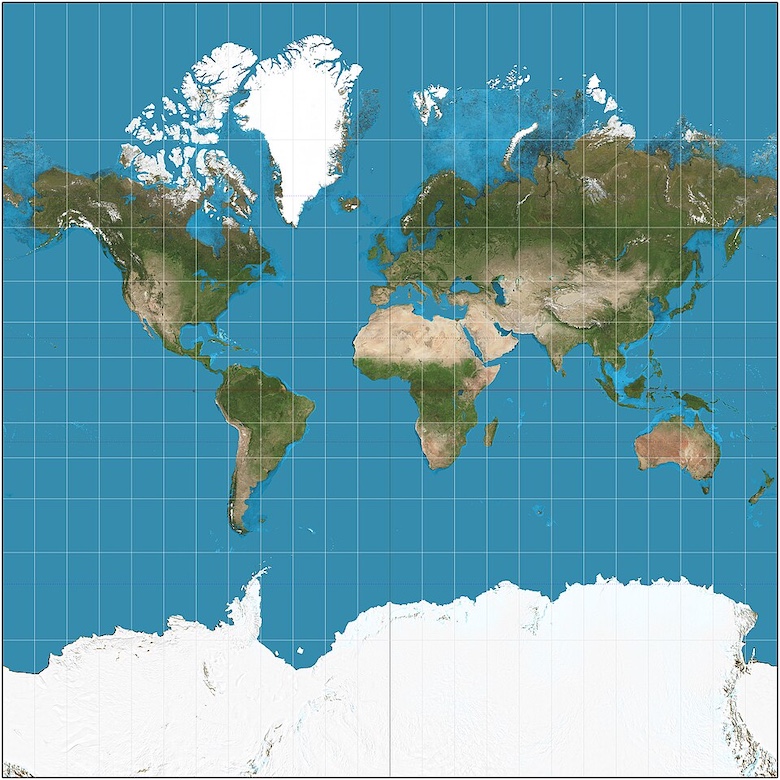
Note that much of the lower half is occupied by Antarctica, which has no native population. Hence many maps cut off the part below the southern tip of South America, thus introducing another lesser-noticed distortion in that the equator is now no longer is in the middle. If you are not aware of this, you may think that the equator lies higher than it really is, and passes through the wrong countries.
I came across another map that seeks to correct misapprehensions about the sizes of countries.
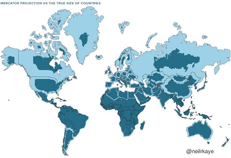
Maybe someone should show Trump this map and remove at least one crazy idea from his ignorant brain. But he will hate it because it makes the US smaller.
Are we pretending that Trump is capable of telling the difference between the two different representations?
We’re talking about a guy who only recently learned the definition of “groceries”, so…
A couple of years ago, I would not believe Trump could be that stupid. Now, I consider it completely plausible.
I clearly need to get a globe…
I knew Greenland (and Antarctica) were overly distorted, but this map shows me several misconceptions I’ve always had, I always assumed that:
-- Canada was larger than the US, if less populated
-- Sweden was larger than Germany+France, if less populated, same for Finland
-- Norway was larger than France
-- Russia was larger than US + Canada combined
-- The former USSR was about 3 times the size of China, instead of 2 times…
Oddly enough, I suspect all assumptions might actually be valid if the equator were to run halfway through the antarctica-exluded map instead of 1/3rd through the bottom.
Well, at least one of them holds. Canada is slightly larger than USA (1.5%).
roberto@3
At 9,984,670 square kilometres Canada is slightly larger than the USA (9,833,67 square kilometres)
Well did anyone doubt that? Granpaw Pudding-for-brains happened to glance at a map, saw Greenland and started squalling BIG! ME WANT!
Plus, some of his slimy, poisonous courtesans/asslickers will probably have hatched some plans on how to profit from a Greenland takeover. Big gamble yes, but larceny is all they know so why not bet big?
i’ve always seen this as his shit poker face. tell the rubes global warming is fake, try to snatch florida north while the snatching is good, and laugh at miami atlantis from el castille de nuevo mar a lago. he is in turn being conned by whichever wormtongue is telling him anywhere at all will be safe from the damage of climate change.
A Different Bias:
Trump’s Greenland Tariffs: The Reality Check
.https://youtube.com/watch?v=WWIRZ-FyT7s
This is somewhat more optimistic as it seems Trump is not quite as reckless in regards to Greenland as with Venezuela. But EU/NATO needs to get their message across to the Republicans before Trump moves.
That is really interesting about maps, Mano! I didn’t know that.
I am worried for Greenland, trying to think what Trump will do.
If his generals or joint chiefs of staff or whomever they are, are still some of the people from his last term, they may rein him in. Any general, etc., who is sane will be horrified at the idea of having some sort of military tussle with NATO, or Europe, even just military displays. It would upend all of the status quo, which is what the brass likes and wants. So, I’d think that they’d try to talk (meaning, lie) him out of it, perhaps throwing in a performative gesture or two (how about assassinating the president of Iran instead? The military brass distracted Trump last time by letting him kill a random Iraqi general.)
The brass *may* even refuse to obey his “illegal” orders if he wants to send troops or bombs. It seems as though, during his last term, they might have done that perhaps twice. While Venezeula allegedly has something to do with drug traffic, *and* isn’t in NATO, *and* we’ve just flat-out invaded South and Latin American countries so often, the brass may have been fine with that. But, Greenland may be different.
If the brass can get Trump into “talks” (he seems to think that it’s a monetary transaction? So, tell him it’s a sales negotiation?), any good diplomat(s) can make those go winding on forever, or, at least until Trump is dead. That’s what diplomats do: they talk people to death.
The EU and Canada and Japan always could play their ace again, start to very slowly and quietly sell off their US Treasury bonds. Not enough to crash the global economy, just a little, just enough to cost Trump a lot of money, with the threat, of course, of continuing it.
The rest of the world has to start doing something sometime, they are not going escape the consequences of insane fascism.
Dear Mano, thanks for finding showing us that more accurate map. It proves how important having a correct perspective is.
Of course the problem is that the mass of tRUMP’s ego is larger than the land mass of any nation. More and more he acts as if he considers himself the emperor of the entire world. Congress is useless. Main stream media is useless. When the courts rule against him he just ignores them. The chaos perpetrated by him and his hateful sycophants seems to just increase everyday. I just wish we could find some safe and truly effective force that could deflate that monstrous, murderous ego.
The EU should buy Florida. Does anyone know what the Seminoles are asking for it?
Reminds me of my grandfather showing me a globe when I was a kid: “See that tiny speck here? Thats Germany. And we thought we could fight against all the rest of this big world.Do you see how insane that is?”
I really wonder where this whole Greenland fiasko actually comes from. Is it simply a product of Trumps decaying brain or do any of his handlers believe there is a profit in it for them? Or are Dumpf and the people behind him equally stupid and delided so it doesn’t make a difference?
∞ – 1 = ∞
Oh lovely. A prominent* member of the current German government has declared that Dumpf’s demands for Greenlad are actually reasonable and justified. Do I need to mention he’s a christian conservative?
(*) Mainly for being corrupt.
Trying to explain this level of geometric complexity to Donnie would be like trying to explain calculus to a cat.
Apparently Ronald Lauder--the son and heir of Estee Lauder the makeup and perfume empire--has known Trump for 50 years and whispered in his ear about buying Greenland for the spring water (sales to luxury-minded customers) and other uses. He also egged Trump on to acquire Ukraine’s minerals.
Guardian story here with no paywall.
I think we need to jettison this idea that Trump wants Greenland because he secretly knows climate change is real and is planning for the future. It’s comforting to think that he’s actually got a reason for all this and a long term plan but it’s pretty clear neither of those are true. This is the same man who tells us what he wants even when that makes him far less likely to get it. Who gave Bondi her marching orders to charge Letitia James and James Comey publicly. Who openly read an obviously private note passed along by Marco Rubio like a cruel teacher who wanted the whole class to know. Go watch that clip again and then tell me you really think he could talk about anything he wants as much as he’s talked about Greenland without any secret motives.
He isn’t planning for climate change because he either really believes it’s a hoax or he has accurately determined that he won’t be living through the worst of the damage he’s causing. He can’t even plan two weeks ahead. Remember when he was going to have a healthcare plan in two weeks? Early on in his first term? Yeah, that sales pitch he tried to pass off as a healthcare plan recently was just him promising that Congress would make a plan because he didn’t have one.
Wisely planning ahead is not something Trump is good at. If he were, he wouldn’t have gone through so many bankruptcies.
Just for the sake of completeness:
https://svs.gsfc.nasa.gov/3540/
@garnetstar #9: The problem with generals reigning in Trump is that Hegseth was specifically hired to tell Trump that the generals were no talent stooges who were just grifting for a paycheck. Just think about that meeting where Trump and Hegseth talked down to those same generals and other military leaders you hope will stop him.
Both Trump and Hegseth also strongly implied that anything they didn’t want to hear would be considered political speech and subject to serious disciplinary action. They’re also willing to go after pensions as seen with Senator Mark Kelly.
We already know Trump believes Fox News personalities over experts. All he cares about is his ego so what use to him is expertise that can prove him wrong when he can have yes men willing to insist he’s always right?
I’d really like to be wrong but I’m afraid I might not be.
LIVE: Nigel Farage Heads to Davos to Screw Greenland Over
.https://youtube.com/live/J9iT-oEb4Ac
Comment # 3
For chrissake, someone stop Farage before he can cause even more damage.
Isn’t Davos full of alps with, like, steep cliffs? (Hint, hint)
I have to disagree with your there, Mano. There is no such evidence. Lawrence O’Donnell thinks the whole Greenland thing is just to distract from Epstein, and that he will never do anything about it. Distraction may be part of it, but the tariff threats -- which have caused a blip in the stock prices, which Trump thinks are the most important measure of economic success -- suggest otherwise. And what could be a greater distraction than actually invading Greenland and collapsing NATO? Other than using a nuke, which I think he is also itching to do. I also think Vance may be egging him on in this case: he hates Europe and Europeans, is at best indifferent to NATO, and may see Greenland as a way to destroy the EU (Orbán has already said it’s not an EU issue, other EU members may follow as the threatened tariffs will affect all EU states). Notice that Vance intruded himself into the negotiations that were supposed to be headed by Rubio.