Fuel Rats. Eeeeeeeeeeeee. And a dread elder god of my very own. Many thanks to Marcus. Click for full size.


© C. Ford.
Fuel Rats. Eeeeeeeeeeeee. And a dread elder god of my very own. Many thanks to Marcus. Click for full size.
© C. Ford.

Julie Anand and Damon Sauer, “Calibration Mark AD48 with Satellites,” from Ground Truth: Corona Landmarks (courtesy the artists).
Strange colossal shapes dot the Sonoran Desert in Arizona, x-shaped relics of a once top-secret Cold War spying project. Known as the Corona program, the surveillance initiative by the CIA and US Air Force involved using satellites to take aerial photographs of the Soviet Union and the People’s Republic of China. The cameras on these satellites were calibrated with concrete crosses 60 feet in diameter. Their exposed 70mm film was later jettisoned in space, the parachuting capsules caught in mid-air by plane. The calibration markers helped assure that the film was in focus, and that there was a landscape measure to accurately assess the size of pictured objects.
Approximately 256 of these markers were placed on a 16-square-mile grid in Arizona, spaced a mile apart. Long after Corona’s end and its declassification in 1995, around 100 remain. Phoenix-based artists Julie Anand and Damon Sauer have spent three years tracking them down for a project called Ground Truth: Corona Landmarks.
You can read all about this, and see more at Hyperallergic.

Painted bodies, fire-breathers, burlesque dancers, freaks plus the finest club sounds – Roll up, Roll up! Into our magical Wonderland!
Body Circus 2017presented by DIAMOND FX got again a stunning venue. On the east bay of the lake, at the new festival city Klagenfurt you can discover the enchanting castle LORETTO. This majestic venue will host the traditional, surreal and bizarre ball. “Body Circus“ which is traditionally held on Wednesday’s and known as the main attraction of the festival week.
For the 20th edition of the World Bodypainting Festival, once again we invite you to push the boundaries and let your imagination run free. Guests show up in fantasy costumes from Drag Queens to bodypainting, decoration, masks, extreme make-up, bizarre fashion, and latex outfits. Unleash yourself from your normal day surroundings. Dive into a wild night with the most enchanting artists, latest club tunes from our international DJ’s and provocative stage shows. For those who need help or want to get ready with others, the styling jam session is the place to be. Transformed and ready for circus, are also the girls behind the bars, serving Champagne, Cocktails and juggling buckets of Vodka through the dancing crowd filled with decorated bodies – Roll up, Roll up!
You can spend hours checking out the whole scene here. I’d love to go!
Current Hours: 1,247. Skeins Used: 194. Click for full size.

© C. Ford, all rights reserved.

Alexey Kondakov.
Ukranian multimedia artist Alexey Kondakov flexes his Photoshop prowess to take characters from classical paintings and transport them into everyday scenes in his series “Art History in Contemporary Life”. The ongoing project sees the artist take banal photographs of contemporary urban life — from subway cars to waiting rooms and trash-filled alleyways, and inserting figures from paintings by the likes of Bouguereau and Holbein. In doing so, Kondakov creates a playful meditation on the nature of time, overlapping époques and cultural contexts. See more of his work on his Facebook page.
You can see more at iGNANT.

File this under Want. As a whole house full of want. It’s a chair which is also a bookshelf, which is in turn, part of the larger bookshelf. This is brilliance. You can see much more and read all about it at iGNANT.

Danli Hu.
A thought-provoking project by interactive designer Danli Hu reminds us that reality has never been concrete. Made for Hu’s graduate program in Design and Technology at New York’s Parson’s the New School, Touching the Void allows users to feel objects that aren’t really there.
“Humans are visual animals; we rely on our eyes and believe the world is exactly like what we see. We think an object physically exists in our real world because we can perceive it with our eyes and feel it with our hands. Creating a virtual object, which is unseeable but provides physical sensations despite its invisibility, challenges people’s definition about virtual and reality,” explains Hu on her website.
You can see and read more at The Creators Project.
Flowers 4k from Biolapse on Vimeo.
The Pixie Trickster – Fly-through Animation from Steven Shmuely on Vimeo.
I’m just in love with this.

A replica of The Lady of Cao face, a female mummy found at the archaeological site Huaca El Brujo, a grand pyramid of the ancient Moche pre-hispanic culture, is seen at the Ministry of Culture in Lima, Peru July 4, 2017. REUTERS/Guadalupe Pardo.
The discovery of the Lady of Cao’s mummified remains in 2005 shattered the belief that the ancient Moche society, which occupied the Chicama Valley from about 100 to 700 A.D., was patriarchal. Several Moche female mummies have been found since in graves with objects denoting a high political and religious standing.
Archaeologists believe the Lady of Cao died due to complications of childbirth but otherwise lived a healthy life.
Her arms and legs were covered with tattoos of snakes, spiders and other supernatural motifs. Discovered near her funerary bundle was a strangled adolescent, who might have been a sacrifice to guide her into the afterlife, according to the museum at the El Brujo archaeological site where she was found.
The Lady of Cao is a reminder of the complex societies that thrived in what is now Peru long before the Inca empire dominated the Andes or Europeans arrived in the Americas.
The Moche built irrigation canals to grow crops in the desert and were known for their ceramics and goldwork that have been looted from their gravesites.
The replica of the Lady of Cao, a collaboration that included archaeologists, the Wiese Foundation and global imaging company FARO Technologies Inc, will be displayed in Peru’s culture ministry in the capital Lima through July 16. It will later be shown at the museum at El Brujo.
There’s more to read and see at Reuters.
Yeah, I’m working. Christ, I hate being up at this hour.

© C. Ford, all rights reserved.
Salad, for da rats. Yes, still playing with food. Kinda hard to stop.


© C. Ford, all rights reserved.

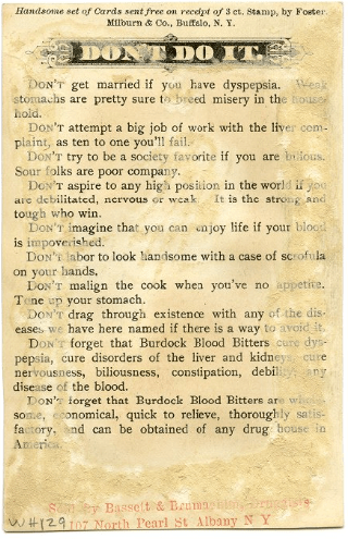
William H. Helfand Collection of Pharmaceutical Trade Cards has been digitized, go have a long look, they are wonderful. I collect old medicines and medical paraphernalia, and these are very hard to come by these days, and a delight to look at.
No, it’s not a hyper-specialised dating service, but a game. It’s only downloadable for Windows, but you can browse the archive no matter the choice of your os.
After digging in the dirt on a solo quest for digital rocks in the “The League of Lonely Geologists,” you may decide to toss one of your finds into the mysterious space portal situated in the otherwise mundane landscape. Immediately, another rock will be hurled back out of this strange gateway, but it won’t be yours. Instead, it’s one found by a previous wanderer of the game, their annotations and specimen name left behind in an ongoing catalogue of the terrain.
Created by Takorii and recently shared by Rock Paper Shotgun, “The League of Lonely Geologists” is available as a pay-what-you wish download for PC. It’s billed as a game of “awkward & uncomfortable rock collection,” yet rock collecting is only part of its mechanics, which are revealed through experimentation. Toss a plant into the portal, and get a phonograph cylinder back, which may play some jaunty tune, or just an eerie hum. Throw in the phonograph, and the moon-like vista may spit out a shiny badge.
While the game can only be played in Windows, anyone can flip through the online catalogue of finds. As of this writing, 669 “geologists” have discovered over 2,000 rocks, such as the “dented lid” that’s “just a trash can lid someone spray painted gold,” and the “unstoppable rock” that’s constantly in motion, and “no obstacle can stop this movement.” Some players take their naming and description more seriously than others, but it’s surprisingly enjoyable to have this kind of anonymous sharing. And like any scientific survey, albeit one steeped in absurdity, it keeps you curious about what else is out there.

