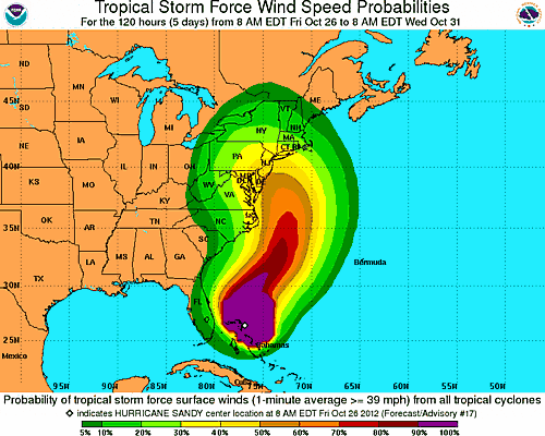
Hurricane Sandy isn’t the latest or strongest Atlantic hurricane, the record-breaking 2005 season included a named storm as late as January 2006! But she may well deliver a wallop to the eastern seaboard residents of New England will not soon forget:
Wind shear is expected to remain a high 30 – 55 knots for the next four days, as Sandy interacts with a trough of low pressure to its west. The high shear should keep Sandy from intensifying the way most hurricanes do–by pulling heat energy out of the ocean. However, the trough approaching from the west will inject into Sandy what is called “baroclinic” energy–the energy one can derive from the atmosphere when warm and cold air masses lie in close proximity to each other. This transition will reduce the hurricane’s peak winds, but strong winds will spread out over a wider area of ocean. This will increase the total amount of wind energy of the storm, keeping the storm surge threat high. This large wind field will likely drive a storm surge of 3 – 6 feet on Monday and Tuesday to the right of where the center makes landfall, on the mid-Atlantic or New York coasts. These storm surge heights will be among the highest ever recorded along the affected coasts, and will have the potential to cause hundreds of millions of dollars in damage.
The latest set of 00Z (8 pm EDT) and 06Z (2 am EDT) computer model runs still have wide differences in the timing and landfall location for Sandy. The ECMWF has been very consistent in its handling of Sandy, and continues to predict that Sandy will hit Delaware or Maryland on Monday afternoon–basically the same forecast it has had for three days. Our other top model for forecasting hurricane tracks, the GFS, has been more inconsistent, and predicts a landfall on Long Island, New York on Tuesday afternoon.


It seems to me that your link to info about the 2005 season goes to the wrong place. It should go to today’s xkcd.
True dat. This is BAD. BAD. The unanimous model consensus has the storm deepening to 940/950 mb, and whapping somewhere. It’s already expanding greatly. I fear for the residents of the area.
It is going to be worse than that.
The forecast is that when Sandy reaches New England, it will collide with a frontal system moving from the west coast and an arctic blast coming out of Canada. Imagine: three major storm systems meeting up, with any two preventing the third from going anywhere. It will be a very ugly mess.
Arf!
Here in Taiwan, back in August was the strangest passing of a typhoon I have ever seen or heard of: it did a loop and hit Taiwan twice. Maybe it’s happened elsewhere, but never in the decade that I’ve lived in Asia.
There were two typhoons in the Pacific at the same time. The eastern of the two pushed the western one (Tembin) in a south-westerly direction. But as the eastern typhoon passed, the jet stream pushed Tembin eastward again. It went north and hit Taiwan (lengthwise this time) for the second time in a week.
http://en.wikipedia.org/wiki/Typhoon_Tembin_(2012)
I say that not to one-up anyone, but rather as another example that more and more bizarre weather phenomena are happening worldwide.
Ugh, isn’t this scenario similar to the archtype “Perfect Storm”?
After the super-weird thunderstorm we had earlier this year, my grandmother and my brother’s MiL (who both live near DC) have already decided to leave the area this weekend and stay with family all next week. They don’t want none of this nonsense.
@geocatherder #6 – The Perfect Storm of 1991 came together out over the ocean, and the edges of the storm hit pretty rural areas. Frankenstorm is expected to coalesce over one of the most densly populated parts of the United States.
Ever since “The Nightmare Before Christmas” I’ve expected Sandy to launch a retaliatory strike against Hallowe’en…
This is why Mt. Washington, NH, has the wildest weather in the world. Three systems (not as wild as Sandy) come together near there a lot.