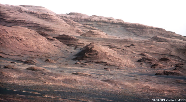
Mars Curiosity is like a super hero probe compared to her less endowed peers and this week she began proving it. While I’m not planetary geologist, that looks like the spittin image of marine strata exposed by some kind of erosion:
Homepage — A chapter of the layered geological history of Mars is laid bare in this postcard from NASA’s Curiosity rover. The image shows the base of Mount Sharp, the rover’s eventual science destination. …
For scale, an annotated version of the figure highlights a dark rock that is approximately the same size as Curiosity. The pointy mound in the center of the image, looming above the rover-sized rock, is about 1,000 feet (300 meters) across and 300 feet (100 meters) high.
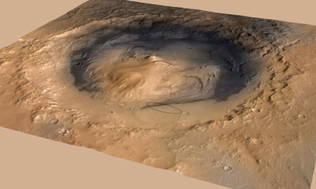
I found the scale explanation a tad confusing. But to get an idea where the rover is and what its looking at, here’s a three d map of the LZ, Gale Crater, with the central mountains obvious and Cursiosity’s position right in the middle of that oval just below center of the shot.
The pile in the middle is called Aeolis Mons. But it’s known more popularly as Mt. Sharp and that’s what the rover is looking it. Distances are hard to judge on Mars, these hills are slumpy and rolling, plus the air can be really clear and it’s super thin to start with.
Bottom line, those cliffs are further away than they look. If I’ve got my distances and conversions right in my head as this is written, something I’m not entirely sure about, the hill tops on the horizon are roughly similar to the Swiss Alps in terms of altitude. These are B-I-G features with B-I-G layering easily visible from 10 to 20 miles.


Curiosity talks as well
http://www.bbc.co.uk/newsbeat/19399703
wont be tuning in for the singing tho’
this is really cool
http://www.bbc.co.uk/news/science-environment-19296006
Photos really mess with the sense of scale anyways. I took some wedding photos in the Rocky Mountains a few years back. WIth digital cameras, you can instantly realize the difference in the visceral sense of scale between taking the photo and looking at it afterwards.
Now I want to see what this looks like as a stereoscopic image.
Small or far away? this explanation doesn’t help.
They should have brought a geologist’s hammer! (Their principal function, as far as I can tell from my father’s photographs, is as an indication of scale.)
Had you looked at the annotated image?
And how old does it make me if I admit I got the pun?
The thing I don’t get is how do you get a sedimentary design in the middle of a crater?
@ ^ Crissa : Crater forms first, sediments accumulate in it and turn to rock – over millions of years during which Gale crater may have been a cater lake which then froze over and sublimated away or so I’d guess / gather.
‘Spose some ways answering the specifics of your question is *exactly* what that car-sized nuke powered laser armed chemistry mobile lab is there to do!
Love the places our Curiosity takes us!
Typo fix, sorry. Make that :
Gale crater may have been a crater lake which then saw its water / brine / fluid freeze over and then sublimated away leaving the sedimentary rock that had formed inside as its landscape. Plus evapourite minerals maybe? Subsequent aeons of erosion could’ve altered things too.
Aeolis Mons — “Wind(y?) Mountain”?
@ ^ Pierce R. Butler :
http://en.wikipedia.org/wiki/Aeolis_Mons#Name
& see also :
http://en.wikipedia.org/wiki/Aeolians
apparently an ancient Greek tribe / group in Asia Minor.
Plus :
http://en.wikipedia.org/wiki/Aeolus
Mythical “ruler of the winds” so perhaps mountainof tehrulerof tehwinds would be more accurate but tobe honest I’m stillnot 100% sure. Not a Greek speaker myself either, I’m afraid.
Aarrgh. Typos. I’ve gotta remember to preview, sorry.
Aeolus = the Mythical “Ruler of the Winds” so perhaps “Mountain of the Ruler of the Winds” would be more accurate? Although, to be honest, I’m still not 100% sure.
Not a Greek speaker myself, I’m afraid. Perhaps someone reading this who is can enlighten us further?