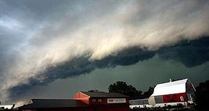
It’s rather beautiful in its alien cloudy-ness. The Derecho. A rare phenomenon characterized by a shelf of low, ominous clouds leading sustained winds, at times exceeding hurricane strength, trailing thunderstorms and sometimes hail in its wake. An unusually violent and gigantic Derecho was herald for some of the storms that hit the east a few days ago (I think I flew through one of these once, see below). Speaking of weather, we keep on rolling snakes eyes:
WunderBlog — Thanks in part to the historic heat wave that demolished thousands of high temperature records at the end of June, temperatures in the contiguous U.S. were the warmest on record over the past twelve months and for the year-to-date period of January – June, said NOAA’s National Climatic Data Center (NCDC) on Monday. June 2012 was the 14th warmest June on record, so was not as extreme overall as March 2012 (first warmest March on record), April (third warmest April), or May (second warmest May.) However, temperatures were warm enough in June to set a new U.S. record for hottest 12-month period for the third straight month, narrowly eclipsing the record set just the previous month. The past thirteen months have featured America’s 2nd warmest summer (in 2011), 4th warmest winter, and warmest spring on record. Twenty-six states were record warm for the 12-month period, and an additional sixteen states were top-ten warm. The year-to-date period of January – June was the warmest on record by an unusually large margin–1.2°F.
If you follow climate change deniers, and if 2012 turns out to be the hottest year in the temperature record (1885 to present), then 2013 will represent an outbreak of global cooling and we can all relax.
Back in the go-go 90s I was crammed into the seatless carpeted interior of a Twin Bonanza converted into a jump plane with half a dozen other skydivers. We were flying to a drop zone several hundred miles away, getting close to the LZ, when the pilot told us to look out the window. On one side the weather was sunny and pleasant, the other was blocked by a gun-metal gray wall spanning both horizons and stretching to the sky. Our pilot got on the radio to air traffic control and was directed to one side of the massive formation. He casually called out that we were probably going to cross a shear boundary and we needed to fasten our seat belts.
He pointed the nose of the old plane up a bit and banked slightly right, slamming the throttles down on both engines. The plane jumped, the wall loomed close and closer. In an instant the windows dimmed, the cabin went twilight dark. We leveled out at top speed, for a few moments all seemed normal. Then the bottom dropped out, like a roller-coaster going over the top of the hill. Long seconds ticked by and we were stilled floating, right about the time I was starting to panic, the little craft seemed to catch on an invisible groove in the murky air, our weight slammed back punctuated by several bumps and little snapping rolls sharp enough to rattle my teeth. The pilot nodded and everything was fine.
We were all wearing altimeters strapped to our wrists, one jumper looked at his and announced we had lost almost 1000 feet in something like 10 seconds. It’s sobering to think, had that same sequence of events occurred when we were much lower, the plane might not have been able to recover; like flyers say, altitude is your friend.
No way to know for sure, but the cloud wall we hit and the weather behind it sure sounds like the description of a Derecho.


I saw an article last night about how some scientists have gone back and seen that the Roman and Medieval periods were actually hotter than the current period.
Here’s the article.
Katherine:
You might want to check out this site:
http://www.realclimate.org/index.php/archives/2012/07/tree-rings-and-climate-some-recent-developments/#more-12427
It has a more detailed analysis of the study you reference. The argument that orbital forcing in particular appears to be weak:
“Orbital forcing is indeed substantial on the millennial timescale for high-latitudes during the summer season, and the theoretically expected cooling trend is seen in proxy reconstructions of Arctic summer temperature trends (Kaufman et al, 2009). But insolation forcing is near zero at tropical latitudes…”
As is so often the case, it appears that the excerpt from the site you linked does not hold up well on it’s own when put in context.
@eidolon:
Thanks. I heard about it and I know it’s going to be referenced as a ‘see, science says global warming is false’ kind of thing, and I have to defend that. I just haven’t seen anyone talking about it since.
From that article, in the author’s voice: “…prominent alarmist scientists…” tells me that site has a bias.
@davidnangle:
Yea, but you know it doesn’t matter what bias anyone has. It’s going to be parroted as Conservative talking points and my Conservative family members are going to prop it up without knowing the limitations of the information nor the actual science of the matter.
I believe I might have seen a pair of these storms from the ground in Denver sometime in the early 1980’s. Instead of the more normal “anvil” shaped thunderstorm these were a wall like you described. The first one formed over the northern suburbs of the metro area, followed by another less than an hour later. There were high winds and baseball sized hail, which really trashed houses, trees, and cars. I was glad that I had a side view.