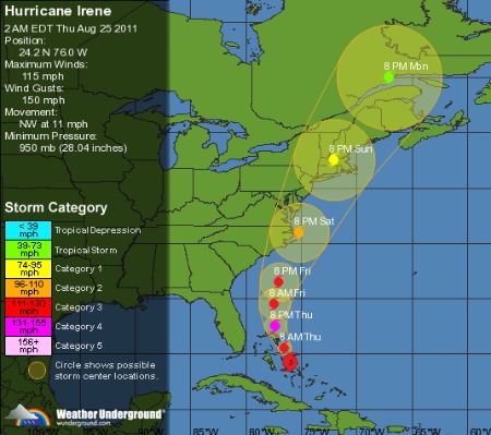
Hurricane Irene remains a Category 3 storm and is forecast to briefly achieve Cat 4 status over the next day or two. The latest 5 AM EDT update from the National Weather service agrees closely with the image above: Irene is on track to buzz essentially the entire mid and upper US east coast and could make two landfalls, one near North Carolina’s outerbanks and the second near Long Island, New York. Typically, the maximum winds and storm surge of a hurricane traveling north will fall to the east of the eye and max rainfall to the west. A shift of just 50 miles spells the difference between a multibillion dollar disaster and less than a billion.
Via the WeatherUnderground early this morning:
The different forecast models are still in fairly good agreement about Irene’s track through the Bahamas and along the east coast of the US. The 00Z GFS run is in close agreement with the 12Z ECMWF run, but the 00Z ECMWF run is continuing the ECMWF’s trend of shifting the track westward with each run. NHC forecasters have been placing emphasis on the ECMWF’s forecast track when making their forecasts for IRene, so it is possible that the NHC track will shift westwards at the 5AM update.
Residents in mobile homes, low laying areas, near waterways and the coast, along with those dependent on reliable power for medical or other reasons, should now make preparations to leave the immediate vicinity of the storm’s path. Any residents choosing to remain should know where local storm shelters are located and be prepared for at least several days without power, water, Internet, and phone.
Update 9 AM EDT: A reader at Daily Kos writes in comments:
A Cat 2 actually hitting NYC would be awful. The winds between the buildings would be even faster, and there would be tons of things flying through the air that could kill people. You’d really not want to have anybody at all on the streets, which is practically unimaginable for New York. Windows in NY are not storm-proof, so there would likely be great breakage (yet another danger for those on the ground). The bottom line is that New Yorkers are not hurricane-experienced and would be very surprised at just what a sustained 100+ mph wind can do.


Leave a Reply
You must be logged in to post a comment.