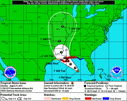
As of PM Eastern Time the National Weather Service shows Hurricane Isaac tracking true and steady for landfall smack dab on the Mississippi delta and passing right over New Orleans on Wednesday morning, seven years to the day Katrina hit that same spot. The landfall range at this juncture is not a lock, the storm could wobble and drift; if it does come close it matters a great deal exactly which side of the city the eye passes over. If Isaac’s center passes just to the east it means the traditionally weaker side of the storm hits NOLA proper. If Isaac jogs a bit to the west that would take the most powerful part of the eye wall right over the heavily populated, low-laying sections that were flooded in 2005.
The good news is, currently, Isaac is not likely to be a major hurricane, i.e. cat 3 or greater. Via Dr. Jeff Masters at the WeatherUnderground:
The closer Isaac gets to landfall without having formed an eye, the better it is for intensity at landfall. Isaac has strengthened only modestly in the past 24 hours, and is still struggling with a less-than-conducive atmospheric environment. The HWRF remains on the high end of the intensity spectrum, suggesting Isaac will be a weak category 2 upon landfall. Other models suggest it will be a strong category 1, but the difference is splitting hairs. The National Hurricane Center’s official forecast is for Isaac to continue strengthening over the next day, reaching category 2 at landfall.


I may go watch the surfers at End of the Island tomorrow. Should be some decent waves but Isaac’s staying plenty east of Galveston.
Around here people usually go for duration rather than big waves since there aren’t any big waves here except when a storm is in the Gulf. A lot of people like to surf ship’s wakes in Galveston Bay.
Still a TS darkside Hurry Cane is a bit premature though we’ll see what tomorrow brings. I still have a cousin living in NOLA, well Metairie actually, and she tells me that no one is all too bothered but pretty well prepared as it looks like a very wet storm as the lower intensity ones tend to be.
Everyone stay safe. It’s low intensity, but that doesn’t mean damage won’t be bad. Katrina wrecked NOLA, but other places hardly had any trouble. Then Gustav, a weaker storm, wrecked Baton Rouge and NOLA was only bad off because they still hadn’t recovered from Katrina. You never know.